Here are my lecture notes: it's nice to be in class again after all these years. William Fox is MC.
Cognitive dissonance in isotropic spaces. Imagine you're driving through a desert. You see some nice mountains. You assume they are two miles away at most so you park the car and start walking. Then three hours later the mountain patrol has to come and rescue you. You can't scale your limbs to the limbs of the trees. And in the desert colors stay the way they are in the distance, violating atmospheric perspective (things bluer in distance). It's not green, either. You don't understand the color. Aboriginal and indigenous people have other ways to navigate than laying a grid out on the land.
John Reed's Fish Man project, creating a national park by setting up a Bigfoot-like story about the last existing hominid.
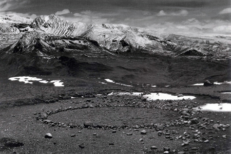
Chris Drury. Spiral figure on a dry lake bed north of Reno.

Claude, Rest on the Flight into Egypt. Landscape as scenery for Biblical action. “Landscape” painting. A backdrop like place. Scenery.
For an anthropologist it's a conceal-and-reveal landscape: you can hide, peer, without being seen. If you're an early hominid, hiding behind a tree, you want to be able to see your food and water without being seen. This kind of organization is very very old. Hard wired.
You can ask anyone around the world and this is what they want: foliage in the foreground, water out there somewhere, preferably important, and some mountains in the distance.
Blue mountains: we are scaled to it. We know what relationship of distance to time is figured there.
But in an isotopic landscape, e.g longest transverse sand dunes on Earth (Australia). Trouble navigating through it if you're white western European. Aboriginals know how to dance through it: they tell stories through dance. Feet dots in sand make a map, telling you what food you can eat. What in neighbor's territory you can eat. How to marry, who to marry. Etc.
Then dot painting, like the marks in the sand. Painting the stories of the dreamtime since the 1970s. Look at a painting and hear a song, rules of the country. Information encoded in the painting about waterholes and how to get there.
Maureen Samson, an amazing aboriginal painter. She isn't painting dot paintings strictly anymore. Train driving through the picture. Australia is red because of all the iron. “They are taking away my country.” The longest trains in the world. Literally scooping the country up and sending it to China.
So, how do we organize a system of the world in science and art, in the Anthropocene?
Earth systems science late 1700s plus. And the art that goes in sync with that.
His proposal is that artists and scientists are always working together to cognitively map the world.
3 stages of Anthropocene with 3 techs of representation. Painting and drawing; photography; multimedia and landwork. The techs didn't kill one another.
Alexander von Humboldt. A Prussian, he is the heir of a young family. He becomes a mining engineer. Studies painting, drawing, music, architecture. He inherits the fortune. Decides he wants an adventure. He can get into South America getting through British blockade of Venezuela.
Going up the Orinoco River. Make first map of interior of South America that has any credibility. Samples of every plant. And along the way von Humboldt exercises the male European imperative and decides to climb the highest mountain, Chimborazo—a 20 000 foot mountain in silk shirts...
Climbing up to 19 000. Drawing with schematics: different elevations with different plants. Taking measurements every hour. Von H realizes this is interesting: like in the Alps. The higher you go, the colder it gets and the plants change. It's the same in Europe. So perhaps there are bands of temperature, in which altitude and latitude are correlated in a system of the world.
It's the beginning of physical geography and ecology. Earth systems science. Then he funds people to go around the world collecting this data. This is the platform, foundational pictures of the world.
Producing a multi volume, very very expensive collection of books that synthesizes this. Now we have maps of the world including consumption from 1790, to “the great acceleration” (1950s plus).
Paul Crutzen, scientist who figures out the ozone hole. Nobel Prize 1985. Coins the term Anthropocene in 2000. Holocene, “the recent era.” “I don't think we're in a Holocene, we're in the Anthropocene. Since 1790, when we dig out big amounts of coal, we've been laying down a stratum of soot around the world. You can dig in the Arctic and dig in the lakes, and find this stratum. And that's how you define an era, by looking at a geological stratum.”
(Me: So the ecological era is when we figure this out. Out of modernity.)
By the 1990s we discover it's us, changing the Earth, as part of an Earth system.
Since 1950 behind the world's largest dams (all in the Northern Hemisphere), there is so much water that we have changed the rotation of the planet. The planet is not slowing down. This is not good or bad but we are terraforming the planet.
We realize we are innumerate. We can count to 10, 100, even 1000. We can say “That's roughly a thousand.” We can't look at 10 000. So when you put together a billion people at the height of the Roman Empire: they were shifting as much dirt as dinosaurs in the Pleistocene.
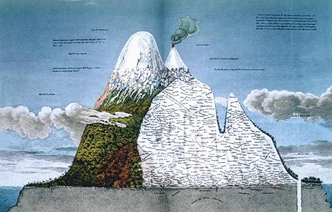
So it helps to have art to visualize it. Humboldt's isotherms. Combining all the drawings of all the mountains. Trying it all together. Saying where people will be found.
1821: A beautiful image that puts together all the world's highest mountains, lines of longitude and latitude, all the climates. Puts a human settlement as high as one can exist.
Goes on to write Cosmos, explaining the Universe...Frederick Church gets inspired. Monster painting at the Met, an idealized view of South America. Unlike the Claude painting however, this one shows you what the landscape looks like. Where the snow line ends. Where the tropics end. The highest place a human could live. Above all else this image is a system of the world:

Church rents out opera glasses for people to look into the picture (not treating it as a picture). He makes almost $10 000...Sells it for $10 000.
Then Bierstadt. Moran (Yellowstone). Not Jackson's black and white pictures but these sorts of painting that persuade Congress to create a national park. Jackson and Moran go out together for the first time to depict geology.
Different theories of how Grand Canyon: catastrophism and uniformitarianism. Isotropic places that you can't scale yourself to.
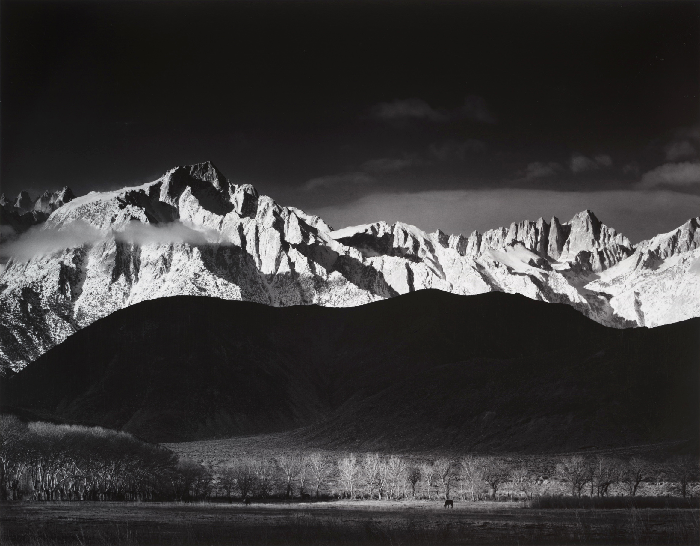
Ansel Adams Winter Sunrise. Pristine aestheticization. Dark foreground. But human made line of trees concealing the aqueduct that takes the water to LA.
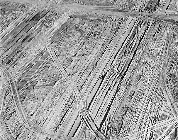
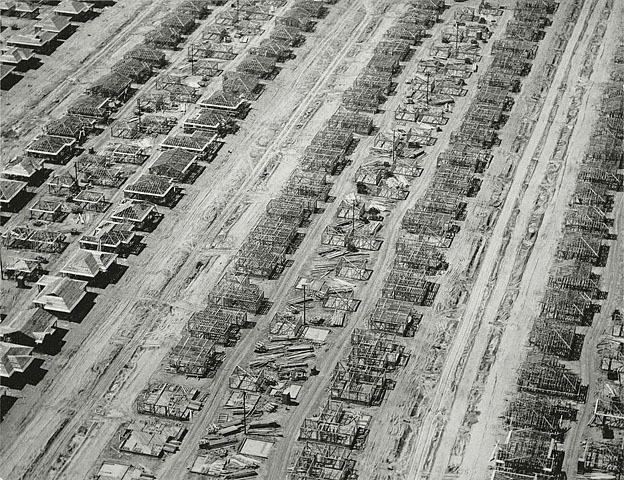
William Garnett. Aerial photography. Photos of Lakewood CA. Navy guys scraping Earth clean, treating it like an assembly line. Foundational documents of urban sprawl.

The Bechers.

Then as the Great Acceleration gets going we start to have artists who also reshape the planet. Frederick Church and Humboldt connecting sky and Earth. Bierstadt. Ansel Adams doing that in a more aesthetic way. Then James Turell, shaving a volcano to create celestial vaulting. Moving the planet to make a piece of art. Not just picturing it.

As we go along in the Anthropocene the artists become part of the process of changing the face of the planet. Michael Heiser:

Richard Long (simple lines, less money in UK in late 60s).

Nazca lines lasted more than 1000 years. A little ring of stones in the Andes that can last 10 000 years.

Richard Box using leaking electricity.

Not a political protest: simply making something visible.
John Wolesley.

Natural historical record of what he's seen. Leaves his drawings in the outdoors for a year.
This etching was made at Baniyala (Blue Mud Bay) in East Arnhemland. I was there for several weeks with Fiona Hall, Judy Watson as the guests of the Community october 2009. All the objects were gathered beside the Bay, and represent the seawrack which is on the edge of the sea. Great Yolngu artists with whom we worked like Djambawa Marawili and Mulkan Wirrpanda ( who has adopted me as Wawa or brother) told me the uses and metaphorical significance of the seeds, plants, turtle shells (the mottled black and white images in the etching) and other specimens For instance the small mangrove leaf in the work in the middle looks rather like a sting ray, and Yolgnu children play with them and reenact the mythic stories about a giant stingray which in the' ' first morning' or Dreamtime surged up into the land and created significant formations in the land. There are also Magpie goose and brolga crane feathers, and the burnt 'hands of sand palms.
Spheres that represent stars by Lita Albuquerque, in Antarctica. Stellar Axis:

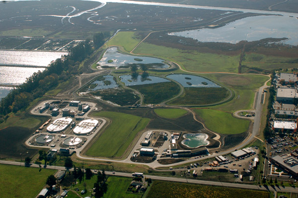
Patricia Johanson. Ellis Creek Water Recycling Facility.
We have cellphones. Cellphones have batteries. Batteries have lithium. Lithium comes from deserts. Fog catchers in Atacama Desert. They work!

2 comments:
Great notes! Thanks, Tim.
Cheryll Glotfelty
From Bruce Chatwin's The Songlines, abouta journey into the Australian outback (pp. 13 ff.):
[Arkady] went on to explain how each totemic ancestor, while traveling through the country, was thought to have scattered a trail of words and musical notes along the line of his footprints ... as ‘ways’ of communication between the most far-flung tribes.
‘A song’, he said, ‘was both map and direction-finder. Providing you knew the song, you could always find your way across country.’
‘And would a man on “Walkabout” always be travelling down one of the Songlines?”
‘In the old days, yes,’ he agreed. ‘Nowadays, they go by train or car.’
‘Suppose the man strayed from his Songline?’
‘He was trespassing. He might get speared for it.’
‘But as long as he stuck to the track, he’d always find people who ... were, in fact, his brothers?’
‘Yes.’
. . . .
In theory, at least, the whole of Australia could be read as a musical score. There was hardly a rock or creek in the country that could not or had not been sung. One should perhaps visualise the Songlines as a spaghetti of Iliads and Odysseys, writhing this way and that, in which every ‘episode’ was readable in terms of geology.
. . . .
‘Put it this way,’ he said. ‘Anywhere in the bush you can point to some feature of the landscape and ask the Aboriginal with you, “What’s the story there?” or “Who’s that?” The chances are he’ll answer “Kangaroo” or “Budgerigar” or “Jew Lizard”, depending on which Ancestor walked that way.”
‘And the distance between two such sites can be measured as a stretch of song?’
Post a Comment